Proppant Research Group
The data displayed below were collected during a joint project between the following departments at Montana Tech of The University of Montana: Geophysical Engineering and the Montana Bureau of Mines and Geology. The samples represent sandstones collected and analyzed for their potential use as proppant material.
| Sample Name | B56-2 | Site Name | B56-JG |
|---|---|---|---|
| Latitude | 45.09648 | Longitude | -108.58505 |
| Geomethod | NAV-GPS | Datum | WGS84 |
| Elevation | 5013 | Township | 08S |
| County | CARBON | Range | 26E |
| 100K Quad | BRIDGER | Section | 31 |
| 24K Quad | BEAR CANYON | Quarter Section | AD |
| Sample Taken | YES | ||
| Sample Date | 8/18/2014 | Formation Name | Tensleep Formation (IPt) |
| Sampler Name | JAY GUNDERSON | Sampler Notes | 1 MI ON HELT RD; TURN LEFT AND GO 1 MI TO NE ON TWO-TRACK ; YELLOW VF GRND QTZ SAND W/ OXIDATION BANDS AND PEA TO MARBLE SIZED CALCITE-RICH NODULES |
| Thickness | 20 | Extent | 9999 |
| References | |||
|
Site Photographs 

|
|||
| Meets API Minimum Standards | Minerology | ||||||||||||||||||||||||||||||||||||||||||||||||||||||||||||||||||||||||
|---|---|---|---|---|---|---|---|---|---|---|---|---|---|---|---|---|---|---|---|---|---|---|---|---|---|---|---|---|---|---|---|---|---|---|---|---|---|---|---|---|---|---|---|---|---|---|---|---|---|---|---|---|---|---|---|---|---|---|---|---|---|---|---|---|---|---|---|---|---|---|---|---|---|
| NO | QUARTZ | ||||||||||||||||||||||||||||||||||||||||||||||||||||||||||||||||||||||||
| Pre Wash Weight (g) | Post Wash Weight (g) | ||||||||||||||||||||||||||||||||||||||||||||||||||||||||||||||||||||||||
| 497.5 | 212.1 | ||||||||||||||||||||||||||||||||||||||||||||||||||||||||||||||||||||||||
| Material Notes | |||||||||||||||||||||||||||||||||||||||||||||||||||||||||||||||||||||||||
|
Sieving Results Reported Sample Weight (g): 104.4
|
|||||||||||||||||||||||||||||||||||||||||||||||||||||||||||||||||||||||||
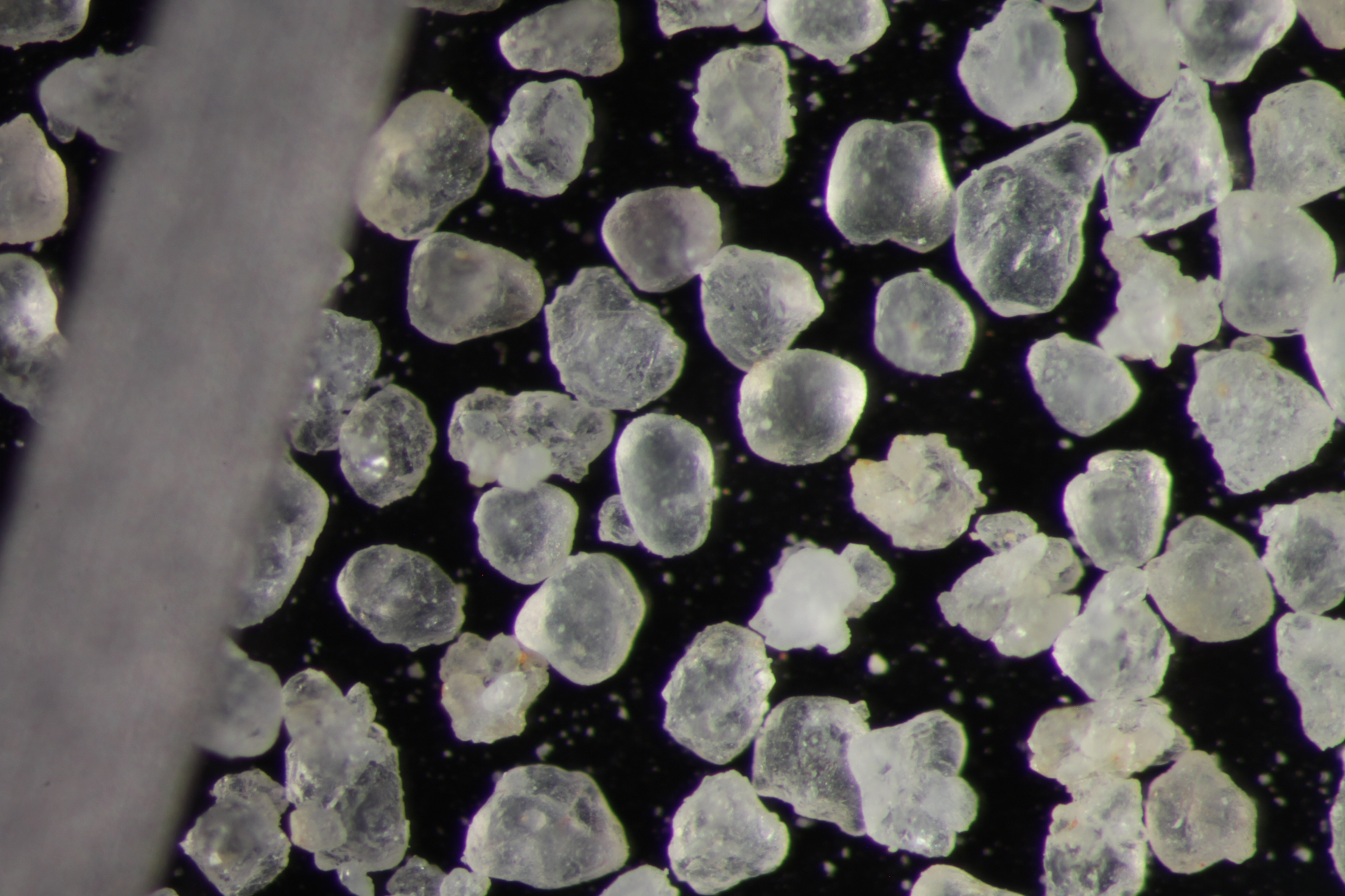
| Sphericity | 0.65 |
|---|---|
| Roundness | 0.66 |
| First Primary | 70 |
| Second Primary | 140 |
|
Available Documents  View document [B56_2_PRECRUSH2015_12_14_9_42_56.pdf] View document [B56_02_SPHER_ROUND2015_12_14_9_44_8.pdf] View document [B56_2_PRECRUSH2015_12_14_9_42_56.pdf] View document [B56_02_SPHER_ROUND2015_12_14_9_44_8.pdf] |
|